Hydrological modelling of Upper Indus Basin Using SWAT model for Last three decades (1994-2023)
Here we will see some results …
Have you ever wondered how the Upper Indus Basin (UIB) has evolved over the past three decades? As one of the most crucial water sources for Pakistan, the UIB plays a vital role in sustaining agriculture, hydropower, and livelihoods. However, the region faces significant challenges due to climate change, sedimentation, and changing hydrological patterns. Understanding these changes is key to ensuring sustainable water management.
This study employs the Soil and Water Assessment Tool (SWAT) to model the hydrological dynamics of the UIB from 1994 to 2023. By integrating long-term climate, land use, and hydrological data, we aim to capture the basin’s evolving behavior, quantify water availability, and assess sedimentation trends affecting reservoir sustainability—particularly in Tarbela Dam, Pakistan’s largest storage reservoir.
Through this research, we not only reconstruct past hydrological patterns but also provide insights for policymakers, water managers, and stakeholders. The findings will contribute to better reservoir management, flood mitigation, and water allocation strategies in an era of increasing climatic uncertainties.
Join us as we dive deep into three decades of hydrological transformation in the Upper Indus Basin—unraveling the story hidden within its rivers, glaciers, and reservoirs.
Factors Contributing to Sedimentation in the Upper Indus Basin
Sedimentation in the Upper Indus Basin (UIB) is influenced by a combination of natural and human-induced factors. Over the past three decades (1994–2023), excessive sediment deposition has significantly impacted Tarbela Dam, reducing its storage capacity and affecting water availability. The key factors contributing to sedimentation include:
1. Glacial and Snowmelt Erosion
- The UIB is home to some of the world’s largest glaciers. Due to climate change, accelerated glacier melt increases the transport of fine sediments into the river system.
- Seasonal variations in temperature influence glacier-fed river discharge, leading to higher sediment loads during summer.
2. Monsoonal and Extreme Rainfall Events
- Intense monsoon rainfall and extreme weather events trigger flash floods, which erode riverbanks and transport large quantities of sediment downstream.
- Heavy rainfall over steep terrains accelerates soil erosion, increasing sediment inflows into reservoirs.
3. Riverbank and Hillslope Erosion
- The Himalayan and Karakoram mountain ranges have steep slopes and fragile geology, contributing to frequent landslides and mass movements that increase sediment loads.
- Unstable riverbanks, especially in high-energy river sections, undergo continuous erosion, exacerbating sedimentation.
4. Deforestation and Land Use Changes
- Deforestation for agriculture, infrastructure development, and urban expansion reduces vegetative cover, making soils more vulnerable to erosion.
- Land use changes, including overgrazing and improper agricultural practices, disturb natural sediment transport processes.
5. Human Activities and Infrastructure Development
- Road construction, mining, and excavation disturb natural land surfaces, increasing sediment yield.
- Poorly managed agricultural practices, including overgrazing and inefficient irrigation, degrade soil structure, making it more prone to erosion.
6. Hydrodynamic Changes in Reservoirs
- The operation of Tarbela Dam and other reservoirs alters the natural flow regime, influencing sediment deposition patterns.
- Reduced flow velocity in reservoirs causes sediment settling, gradually decreasing storage capacity.
Why Understanding These Factors Matters
By analyzing these factors using the SWAT model, this study aims to:
✅ Quantify sediment transport trends over the last three decades.
✅ Identify hotspots of erosion and deposition in the UIB.
✅ Develop strategies for sustainable reservoir management and sediment control.
Addressing these sedimentation challenges is essential to extend the lifespan of Tarbela Dam and ensure sustainable water management for irrigation, hydropower, and flood mitigation in Pakistan.🌍💧


The Upper Indus Basin (UIB) is a vital water source for Pakistan, supporting agriculture, hydropower generation, and downstream ecosystems. However, the basin faces a critical challenge: increasing sedimentation, particularly in Tarbela Dam, which has been accumulating sediments for the past three decades (1994–2023). This excessive sedimentation leads to:
- Reduced storage capacity of Tarbela Reservoir, affecting water availability for irrigation and power generation.
- Increased flood risks due to decreased reservoir volume, limiting its ability to control high flows.
- Degradation of water quality and aquatic ecosystems, impacting biodiversity and downstream water users.
Despite various studies on hydrological modeling, a comprehensive assessment of sedimentation trends in the UIB using the Soil and Water Assessment Tool (SWAT) remains limited. Understanding spatial and temporal variations in sediment transport is crucial for developing effective reservoir management strategies and ensuring long-term water sustainability.
This study aims to model the hydrological and sedimentation dynamics of the Upper Indus Basin (UIB) over the past three decades (1994–2023) using the Soil and Water Assessment Tool (SWAT). The research focuses on analyzing sediment transport, erosion hotspots, and reservoir sustainability to support effective water resource management and policy decisions.
- Hydrological Modeling of the Upper Indus Basin
- Develop a SWAT-based hydrological model for the UIB to simulate streamflow and water balance components.
- Assess seasonal and inter-annual variations in river discharge over the study period (1994–2023).
- Develop a SWAT-based hydrological model for the UIB to simulate streamflow and water balance components.
- Sediment Transport and Deposition Analysis
- Quantify sediment load variations in the UIB, with a focus on Tarbela Reservoir.
- Identify hotspot areas of erosion and deposition using spatial analysis techniques.
- Quantify sediment load variations in the UIB, with a focus on Tarbela Reservoir.
- Impact Assessment of Climate and Land Use Changes
- Evaluate the effects of climate variability on hydrology and sedimentation patterns.
- Assess the impact of land use and land cover (LULC) changes on sediment dynamics in the basin.
- Evaluate the effects of climate variability on hydrology and sedimentation patterns.
- Reservoir Sustainability and Sediment Management Strategies
- Analyze the long-term sedimentation impact on Tarbela Dam’s storage capacity.
- Propose sediment management strategies to improve reservoir sustainability and optimize water resource planning.
- Analyze the long-term sedimentation impact on Tarbela Dam’s storage capacity.
The findings of this study will provide valuable insights for WAPDA, policymakers, and water resource managers in designing evidence-based strategies for sediment control and sustainable reservoir management in the UIB.
Introduction to Tarbela Dam
Tarbela Dam, located on the Indus River in Khyber Pakhtunkhwa, Pakistan, is one of the largest earth-filled dams in the world and a critical component of the country’s water and energy infrastructure. Constructed in 1976, the dam plays a vital role in irrigation, flood control, and hydropower generation, making it an essential asset for Pakistan’s water security.
Geographical and Hydrological Features
- Location: 35.09°N latitude, 72.70°E longitude
- River Basin: Upper Indus Basin (UIB)
- Catchment Area: ~168,000 km²
- Reservoir Capacity: Originally 13.69 billion cubic meters (BCM), now reduced due to sedimentation
- Annual Inflows: Primarily from glacial melt and monsoonal rainfall
- Outflows: Supports Indus Basin Irrigation System (IBIS) and hydropower generation
Significance of Tarbela Dam
- Irrigation & Agriculture
- Supplies water to over 30 million acres of farmland, ensuring food security in Pakistan.
- Forms a crucial part of the Indus Basin Irrigation System (IBIS), the world’s largest contiguous irrigation network.
- Supplies water to over 30 million acres of farmland, ensuring food security in Pakistan.
- Hydropower Generation
- Installed capacity of 4,888 MW, contributing significantly to Pakistan’s renewable energy sector.
- Ongoing Tarbela 5th Extension Project aims to further increase power output.
- Installed capacity of 4,888 MW, contributing significantly to Pakistan’s renewable energy sector.
- Flood Control & Water Regulation
- Regulates river discharge, reducing the risks of seasonal flooding in downstream areas.
- Acts as a buffer during monsoons, protecting major cities and agricultural lands.
- Regulates river discharge, reducing the risks of seasonal flooding in downstream areas.
Sedimentation Challenges
Despite its benefits, sedimentation poses a significant threat to Tarbela Dam’s long-term sustainability: - Storage capacity has declined due to excessive sediment deposition from upstream erosion in the Upper Indus Basin.
- Sedimentation reduces water availability, impacting irrigation, hydropower generation, and flood management.
- Without effective sediment management strategies, the dam’s operational efficiency will continue to decline.
Why Tarbela Dam as a Study Area?
Given its strategic importance and vulnerability to sedimentation, Tarbela Dam serves as an ideal study site for hydrological and sedimentation modeling. This research utilizes the SWAT model to analyze:
✅ Sediment transport dynamics over the last three decades (1994–2023).
✅ Hotspot areas of erosion and deposition affecting reservoir sustainability.
✅ Impact of climate and land use changes on the dam’s performance.
✅ Strategies for sustainable sediment management to enhance Tarbela’s lifespan.
By addressing these challenges, this study will provide scientific insights and practical solutions for policymakers, WAPDA, and water managers, ensuring the continued functionality of Tarbela Dam as Pakistan’s lifeline for water and energy.
The Tarbela Reservoir

Upper Indus Basin
The Upper Indus Basin (UIB) is a crucial watershed in South Asia, covering parts of Pakistan, India, China, and Afghanistan. It serves as the primary water source for the Indus River, supporting millions of people through agriculture, hydropower, and drinking water supply. The UIB is highly dynamic, influenced by glacial melt, monsoon rainfall, and seasonal variations, making it a critical region for hydrological and sedimentation studies.
Geographical and Hydrological Features
- Location: Extends from the Himalayas, Karakoram, and Hindu Kush mountain ranges to the Tarbela Dam in Pakistan.
- Total Area: ~413,000 km²
- Elevation Range: Varies from 2,000 m to over 8,000 m, including some of the world’s highest peaks (K2, Nanga Parbat).
- Major Tributaries:
- Glacier-fed Rivers: Indus, Gilgit, Hunza, Shyok, Shigar
- Rain-fed Rivers: Kabul, Swat, Jhelum
- Glacier-fed Rivers: Indus, Gilgit, Hunza, Shyok, Shigar
- Climate:
- Western UIB: Influenced by westerly weather systems, leading to winter precipitation.
- Eastern UIB: Affected by monsoonal rainfall, causing seasonal floods.
- Western UIB: Influenced by westerly weather systems, leading to winter precipitation.
Hydrological Importance of UIB
- Water Resource for Pakistan
- The UIB contributes 80% of the total Indus River flow, primarily from glacial melt and snowmelt.
- Supports irrigation, drinking water supply, and industrial activities across Pakistan.
- The UIB contributes 80% of the total Indus River flow, primarily from glacial melt and snowmelt.
- Glacier and Snowmelt Dynamics
- Home to over 5,000 glaciers, including Baltoro, Biafo, and Siachen.
- Climate change has increased glacier melt rates, affecting seasonal river discharge and sediment transport.
- Home to over 5,000 glaciers, including Baltoro, Biafo, and Siachen.
- Sediment Transport & Erosion Processes
- The steep topography and fragile geology of the UIB make it highly susceptible to erosion, landslides, and debris flows.
- Heavy monsoon rains and glacial melt contribute to high sediment loads, impacting Tarbela Dam’s storage capacity.
- The steep topography and fragile geology of the UIB make it highly susceptible to erosion, landslides, and debris flows.
Challenges in the UIB Watershed
- Climate Change Impact: Rising temperatures are accelerating glacier retreat, altering the hydrological cycle.
- Sedimentation Issues: Increased soil erosion and sediment deposition threaten Tarbela Dam and downstream water availability.
- Extreme Events: Higher frequency of floods, glacial lake outburst floods (GLOFs), and droughts due to climate variability.
- Water Management Issues: Need for sustainable water allocation, as demand increases for agriculture, energy, and urban sectors.
Why Study the UIB Watershed?
Given its hydrological complexity and strategic importance, the Upper Indus Basin is an ideal watershed for hydrological and sedimentation modeling using the SWAT model. This study aims to:
✅ Analyze past and present hydrological trends (1994–2023).
✅ Quantify sediment transport and deposition patterns in the basin.
✅ Assess the impact of climate and land use changes on water resources.
✅ Develop strategies for sustainable watershed management to support Tarbela Dam and downstream water users.
The findings will provide scientific insights for water managers, policymakers, and researchers, helping to improve sediment management, reservoir operations, and climate adaptation strategies in the Upper Indus Basin.
1. Digital Elevation Model (DEM)
- Dataset Used: SRTM 30m
- Source: USGS Earth Explorer
- Purpose:
✅ Defines watershed boundaries and river networks.
✅ Provides elevation, slope, and flow direction for hydrological simulations.
2. Climate Data (Precipitation, Temperature, etc.)
- Dataset Used:
- ERA5 Reanalysis Data (1994–2023)
- Purpose:
✅ Provides daily precipitation, temperature
✅ Essential for evapotranspiration and runoff calculations in SWAT.
3. Land Use / Land Cover (LULC) Data
- Dataset Used:
- GlobCover 2009 (ESA)
- Purpose:
✅ Defines land cover classes (forest, agriculture, barren land, etc.).
✅ Impacts infiltration, runoff, and erosion processes in SWAT.
4. Soil Data
- Dataset Used:
- FAO Soil Database (HWSD v1.2)
- Purpose:
✅ Provides soil texture, permeability, and organic matter content.
✅ Influences water retention, infiltration, and sediment detachment rates.
5. Hydrological Data (Discharge & Sediment)
- Dataset Used:
- WAPDA Streamflow and Sediment Load Data (Tarbela and upstream stations)
- WAPDA Streamflow and Sediment Load Data (Tarbela and upstream stations)
- Source: WAPDA (Water and Power Development Authority)
- Purpose:
✅ Used for model calibration and validation.
✅ Compares simulated and observed streamflow & sediment transport.
7. Reservoir Operation Data
- Dataset Used:
- Tarbela Reservoir Inflow, Outflow, and Storage Data
- Source: WAPDA
- Purpose:
✅ Simulates the impact of reservoir operations on downstream hydrology.
✅ Assists in assessing sedimentation effects on storage capacity.
Why These Datasets?
The selected datasets provide a comprehensive input for SWAT modeling, ensuring:
✅ Accurate watershed delineation and flow routing.
✅ Reliable climate and hydrological simulations.
✅ Detailed sedimentation and erosion analysis.
✅ Improved decision-making for reservoir sustainability.
This integration of remote sensing, GIS, and field-based datasets enhances the hydrological and sedimentation modeling of the Upper Indus Basin, supporting sustainable water resource management.
Meteorological Data:
Table 1: Climatic Data Stations| No | Station_Name | Latitude | Longitude | Elevation |
|---|---|---|---|---|
| 1 | Gilgit | 35.92019 | 74.30801 | 1430 |
| 2 | Gupis | 36.21060 | 73.44215 | 2400 |
| 3 | Bunji | 35.64948 | 74.63246 | 3750 |
| 4 | Hunza | 36.31554 | 74.65022 | 2500 |
| 5 | Astor | 35.35697 | 74.86241 | 1585 |
| 6 | Skardu | 35.32131 | 75.55142 | 2228 |
| 7 | Chilas | 35.42858 | 74.11227 | 1160 |
| 8 | Besham | 34.91107 | 72.86632 | 580 |
Table 2: Meteorological Input Data downloaded from Google Earth Engine for SWAT Run| No | GEE_Bands | Satellite | Units | Spatial_Resolution | Temporal_Resolution |
|---|---|---|---|---|---|
| 1 | Total_precipitation_sum | ERA5-Land | (mm/day) | 9x9 km | Daily |
| 2 | Temperature_2m_min | ERA5-Land | °C | 9x9 km | Daily |
| 3 | Temperature_2m_max | ERA5-Land | °C | 9x9 km | Daily |
1. Introduction to SWAT Model
The Soil and Water Assessment Tool (SWAT) is a semi-distributed, process-based hydrological model designed to simulate:
✅ Hydrological processes (precipitation-runoff, evapotranspiration, infiltration).
✅ Sediment transport and deposition in watersheds.
✅ Land use and climate change impacts on water resources.
This study applies SWAT modeling to the Upper Indus Basin (UIB) for hydrological and sedimentation analysis (1994–2023), with a focus on Tarbela Dam.
2. SWAT Model Setup
Step 1: Watershed Delineation
- Input Dataset: Digital Elevation Model (DEM) (SRTM 30m).
- Process:
✅ Define watershed boundaries and sub-basins using DEM.
✅ Extract river networks and drainage patterns.
✅ Identify outlet points at Tarbela Dam and key hydrological stations.
Step 2: Hydrological Response Unit (HRU) Definition
- Input Datasets:
- Land Use/Land Cover (LULC) –ESA GlobCover.
- Soil Data – FAO HWSD
- Slope Data – Derived from DEM.
- Land Use/Land Cover (LULC) –ESA GlobCover.
- Process:
✅ Classify HRUs based on unique combinations of land use, soil type, and slope.
✅ Each HRU represents a homogeneous hydrological unit influencing runoff, sedimentation, and nutrient cycles.
3. Climate and Hydrological Data Integration
Step 3: Climate Data Processing
- Input Datasets:
- ERA5 Reanalysis Data (1994–2023) – Precipitation, Temperature
- Process:
✅ Prepare daily time series for precipitation and temperature.
✅ Interpolate missing climate data using SWAT’s built-in weather generator.
Step 4: Hydrological & Sediment Data Processing
- Input Datasets:
- WAPDA Streamflow Data (1994–2023).
- Tarbela Dam Inflows/Outflows.
- WAPDA Streamflow Data (1994–2023).
- Process:
✅ Format and integrate streamflow & sediment data for SWAT calibration.
✅ Compare simulated vs. observed data for model validation.
4. SWAT Model Calibration and Validation
Step 5: Model Calibration
- Software Used: SWAT-CUP (SUFI-2 algorithm).
- Process:
✅ Calibrate streamflow and sediment yield using sensitive parameters (e.g., CN2, SOL_AWC, ALPHA_BF).
✅ Adjust model 22 parameters to match observed discharge trends.
✅ Use objective functions (NSE, R², PBIAS) to assess model accuracy.
Step 6: Model Validation
- Process:
✅ Validate model performance with independent time periods (e.g., 1994–2008, 2009–2023).
✅ Compare simulated outputs with WAPDA streamflow data.
✅ Fine-tune parameters to minimize errors and improve model efficiency.
5. Scenario Analysis and Model Application
Step 7: Land Use and Climate Change Impact Assessment
- Land Use Change Scenarios:
- Evaluate historical (1994–2023) and projected land cover changes.
- Assess impact on runoff, infiltration, and erosion rates.
- Evaluate historical (1994–2023) and projected land cover changes.
- Climate Change Impact Assessment:
- Analyze temperature and precipitation trends over three decades.
- Evaluate glacier and snowmelt contributions to streamflow.
- Analyze temperature and precipitation trends over three decades.
Step 8: Sediment Management Strategies
- Evaluate Reservoir Sedimentation Trends
- Identify critical sediment sources in the UIB.
- Assess reservoir storage loss at Tarbela Dam.
- Identify critical sediment sources in the UIB.
- Suggest Erosion Control Measures
- Implement vegetative buffers, soil conservation techniques, and watershed management practices.
- Propose sediment flushing and dredging strategies for Tarbela Reservoir.
- Implement vegetative buffers, soil conservation techniques, and watershed management practices.
6. Expected Outcomes and Policy Implications
✅ Improved hydrological and sedimentation modeling of the Upper Indus Basin.
✅ Identification of erosion-prone areas contributing to Tarbela Dam sedimentation.
✅ Impact assessment of climate change on glacier-fed hydrology.
✅ Recommendations for sustainable water and sediment management in the UIB.
By integrating SWAT modeling, GIS, and remote sensing, this research will provide valuable insights for policymakers, WAPDA, and water managers to ensure the long-term sustainability of Tarbela Dam and Indus River water resources.

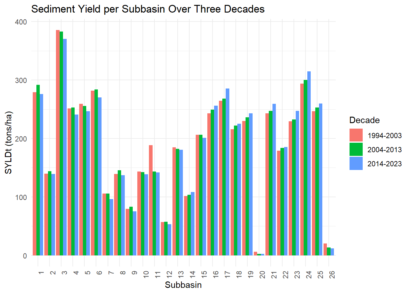
Spatial trend Analysis of Precipitation, Snowmelt, Water yield, Sediment yield and Sediment deposited in channels from 1994-2023
1. Precipitation Trend
- The analysis indicates a declining trend in precipitation over the three decades (1994–2023).
- The first decade recorded the highest precipitation, while the last decade showed a significant decrease.
- This suggests potential climatic shifts, changes in monsoon patterns, or increased variability in rainfall distribution over the Upper Indus Basin.
- Reduced precipitation directly impacts surface runoff, water yield, and overall water availability in the basin.
2. Snowmelt Contribution
- Snowmelt contributions have shown fluctuating but slightly declining trends over the decades.
- Higher snowmelt in the earlier decades correlates with greater water availability in the river system.
- A decreasing trend in snowmelt could be linked to climate change effects on glacial melt rates and seasonal temperature variations in the Upper Indus Basin.
3. Water Yield Trends
- Water yield has gradually decreased, reflecting the decline in precipitation and snowmelt.
- The decreasing trend suggests potential reductions in groundwater recharge and surface water availability, impacting hydropower generation and irrigation.
- This decline may lead to increased water stress in downstream regions.
4. Sediment Yield and Deposition
- Sediment yield has varied across decades, with fluctuations driven by changes in precipitation, land use, and hydrological dynamics.
- The last decade recorded a notable reduction in sediment yield, potentially due to decreasing water flows.
- However, sediment deposition in channels remains a persistent challenge, impacting reservoir capacity and water storage efficiency.
- Increased sedimentation poses risks to Tarbela Dam’s storage capacity, potentially reducing its lifespan and hydropower efficiency.
5. Impact on Tarbela Reservoir
- The combination of declining precipitation, reduced snowmelt, and continued sedimentation has serious implications for the sustainability of Tarbela Reservoir.
- A reduction in water inflow coupled with ongoing sediment accumulation may decrease reservoir capacity, affecting Pakistan’s hydropower generation and irrigation supply.
- This highlights the urgent need for sediment management strategies, sustainable watershed practices, and potential adaptations to climate change impacts.
Precipitation
Decade 1
Decade 2
Decade 3
Snowmelt
Decade 1
Decade 2
Decade 3
Water Yield
Decade 1
Decade 2
Decade 3
Sediment Yield
Decade 1
Decade 2
Decade 3
Sediment Deposit in Channels
Decade 1
Decade 2
Decade 3
Static Graphs
Interactive Graphs
Time series analysis of all the SWAT simulated variables from 1994-2023
- This study relies on ERA5 reanalysis data for climatic inputs instead of in-situ meteorological data, primarily due to high costs and limited availability of station-based observations in the Upper Indus Basin.
- While ERA5 provides high-resolution global climate data, it may introduce uncertainties in precipitation and temperature estimates compared to ground-based measurements.
- The model does not incorporate real-time sediment monitoring, which could improve the accuracy of sediment transport and deposition estimations.
- Land-use change impacts have not been explicitly assessed due to limitations in recent high-resolution LULC data, which could refine the analysis of erosion and sedimentation trends.
- Future research should integrate ground observations, remote sensing, and high-resolution climate models to enhance the accuracy and applicability of hydrological simulations in the Upper Indus Basin.
- Integration of Ground-Based Data: Future studies should incorporate in-situ climatic and hydrological data to improve model accuracy and validate ERA5-based estimations.
- Advanced Sediment Monitoring: Establishing real-time sediment monitoring stations in the Upper Indus Basin will enhance the understanding of sediment transport dynamics and improve SWAT model calibration.
- Glacier and Snowmelt Modeling: Incorporating glacier mass balance studies and using coupled hydrology-glacier models will better represent glacial melt contributions to the Indus River.
- Remote Sensing Applications: Utilize high-resolution satellite imagery (Sentinel-2, Landsat-9) for continuous monitoring of land use changes, deforestation, and erosion hotspots.
- Reservoir Sediment Management: Implementing sediment flushing, dredging, or upstream watershed management practices can mitigate sediment deposition in Tarbela Reservoir, ensuring its long-term functionality.
- Climate Adaptation Strategies: Policymakers should develop adaptive water management strategies to address changing precipitation patterns, glacial melt rates, and extreme weather events.
- Decision Support System (DSS): The development of a GIS-based DSS can assist WAPDA, policymakers, and stakeholders in real-time decision-making for sustainable reservoir and water resource management.
- Future Research Directions: Further research should explore machine learning-based hydrological modeling, ensemble climate projections, and scenario-based simulations for better water resource planning in the Upper Indus Basin.
- This study analyzed hydrological trends in the Upper Indus Basin (1994–2023) using the SWAT model, focusing on precipitation, snowmelt, water yield, sediment yield, and sediment deposition.
- The results indicate a declining trend in precipitation and water yield, which can be attributed to climatic variations and shifting monsoon patterns.
- Snowmelt contributions showed fluctuations, highlighting the sensitivity of the basin’s hydrology to climate change and glacial dynamics.
- Sediment yield varied across decades, but persistent sediment deposition in river channels and Tarbela Reservoir poses a serious challenge to water storage and hydropower generation.
- These findings emphasize the need for sustainable watershed management, sediment control strategies, and climate adaptation measures to ensure long-term water security and hydropower sustainability.
- Future research should focus on integrating remote sensing, climate models, and real-time monitoring to develop a more resilient water resource management framework for the Upper Indus Basin.